
Japan has incredible hiking trails for the travel bucket list. The easy accessibility, clean trails, and picturesque mountain ranges and landscapes are top reasons to hike here. It’s a must-visit country for outdoor lovers and avid hikers.
We’ve been to Japan five times and can’t get enough of this country. We try to add a place to go hiking on each visit. It’s refreshing to smell the clean air, get exercise, and see new things along a nature walk.
Where should you go hiking in Japan? The entire country has so many hiking spots so it’ll depend on where you’ll travel in Japan. Don’t worry. We narrowed down the list with the help of our favorite travel bloggers.
Here are the 12 best hikes in Japan to explore. This Japan hiking guide has both day hikes and multi-day hikes and treks so you can easily add one or more to any itinerary. It also includes helpful tips on hiking duration, difficulty, how to get to the trails, and admission cost.
We’re starting the hiking adventure from the Kanto area (Tokyo) and making our way southeast of the island so there is bound to be a hike to catch your eye.
Now, grab your hiking boots and gear, and let’s get ready to hike!
Click on the links to jump to certain areas of this hiking in Japan guide:
*Disclaimer: This post contains affiliate links. As an Amazon Associate, we earn from qualifying purchases. If you click on them and make a purchase, we receive a small commission. There is no additional cost to you. Appreciate the support.
Things to Know Before Hiking in Japan
Before we read about Japan’s awesome hiking trails, here are some helpful hiking tips and what to bring.
- Figure out the transportation to get to the hiking trails. Japan has an efficient transportation system, so you may need to use a combination of trains, buses, and boats to get to the hiking trails. Depending on your itinerary and duration in Japan, we recommend using the Japan Rail Pass (JR Pass) as much as possible to travel throughout the country. You’ll need to order the JR Pass ahead of time to redeem the voucher for a physical pass on arrival. Buy the JR Pass for a discount here.
- Bring a sturdy backpack. Whether you’re on a day hike or a multi-day hike in Japan, hikers need to have a dependable backpack to hold the essential items. If you’re carrying a heavy load, we recommend a backpack that has shoulder and hip belts so the weight of the backpack can be shifted throughout the hike. We use this daypack for every hike: Osprey men and women versions.
- Stay hydrated and bring a reusable water bottle. While convenience stores and vending machines are plentiful in Japan, it may be hard to find a place to find water along the trail. Bring water and use a reusable water bottle to reduce plastic waste.
- Wear hiking boots or sturdy walking shoes. Hiking boots are necessary for hikes with uneven surfaces and dirt paths. You may need waterproof shoes if you plan a hike during the rainy season. Check out our favorite men hiking boots and women hiking boots that we wear. Easier hiking trails require comfy walking or running shoes.
- Check the weather ahead of time and wear appropriate clothing. Depending on the season and the weather, wear appropriate hiking clothes. Wear lightweight, moisture-wicking clothes during the warmer season. Wear layers of clothing and jackets during the wintertime. You’ll need an umbrella and rain gear during the rainy season.
- Bring hiking poles. This is optional as some of the hiking trails will be steep. Hiking poles will help relieve the stress from knees and help with balancing on uneven surfaces.
- Do not litter. When traveling throughout Japan, you’ll notice that there aren’t any trash cans in public places. It’s the same with the hiking trails, so bring your trash with you to dispose of properly at your next destination or hotel.
- Buy travel insurance before your trip. While the chances of injuries will be small, something may happen during the hike and you may need medical attention.
Map of the Japan’s Best Hiking Trails

Click on the map to see a larger view of the location of hiking trails in Japan. Credit: Map data: Google
Hiking in Japan: Kanto Region
Kanto region is one of the largest areas on Honshu Island, the biggest island of Japan. Many visitors start their Japan journey in Tokyo to explore. Thus, we’re sharing hiking in the Tokyo and Chiba area.
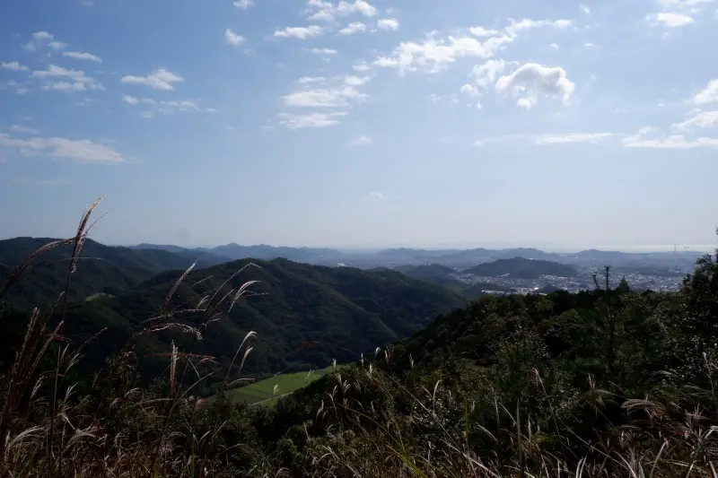
1. Mount Takao
Hiked by Editors, Jackie and Justin, Life Of Doing
Location: Hachioji, Tokyo Prefecture
Round Trip Distance: Various from 6.2-9.8 kilometers (3.8-6.1 miles)
Duration: Various starting from 3+ hours
Difficulty: Easy – Moderate
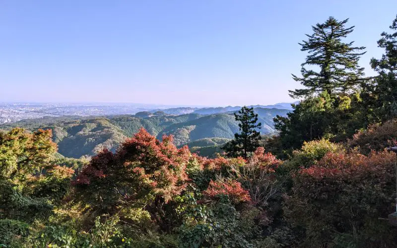
Want to escape Tokyo’s concrete jungles and experience a quick day trip from the main Tokyo area? Let’s go hiking at Mount Takao (高尾山). It’s a unique place to visit as you can wander through 8 hiking trails. The trails are organized by hiking difficulty and distance, so pick one that is suitable for your hiking level. Also, you can try multiple trails as you can go up one and take a different one back down the mountain.
The easiest and less technical trail is Omotesando Trail (Trail #1) as it’s paved and goes through the beautiful Yakuoin Buddhist Temple. Since most people take this trail, it’s very crowded. Another fun stop along the way includes Mount Takao Monkey Park and Wildflower Garden where you can see monkeys in person.
Inariyama Trail is recommended if you prefer walking through the forest area. The dirt hiking path is mostly shaded so it’s a huge reprieve from the heat during the summertime. There are a handful of hikers who take this well-maintained trail.
At Mount Takao’s summit (599 meters/1,965 feet), enjoy the gorgeous landscapes of the forest area. During the springtime, the area is covered with pretty cherry blossoms. The fall season has vivid red and orange leaves in bloom. If you have the munchies, stop by a soba shop to refuel your energy or a snack kiosk for ice cream and baked mochi on sticks.
Hikers who want more of a challenge can continue the hike from Mount Takao to visit Mount Jinba (陣馬山). The summit is 857 meters (2,812 feet) so it’ll be a double leg workout day.
Read more about the Mount Takao hike here.
How to Get There: Take the train to Takaosanguchi Station via Keio Line. Once you exit the station, turn right and follow the walking path to the Mount Takao cable car/ski lift and tourist spot. From there, you can decide which hiking route you want to take.
Admission Cost: Free to access the trail.
- If you prefer to hike one-way, a cable car or ski lift is available. A ride costs 490 yen ($4.50 USD) one-way or 950 yen ($8.75) round-trip for adults and 250 yen ($2.30) one-way or 470 yen ($4.30) round trip for children.
Mount Takao is one of the best hikes in Japan to not miss.
2. Mount Nokogiri
Hiked by Corinne and Jim, Reflections Enroute
Location: Boso Peninsula, Chiba Prefecture
Round Trip Distance: 8-10 kilometers (5-6.2 miles)
Duration: At least 90 minutes round trip
Difficulty: Easy – Moderate
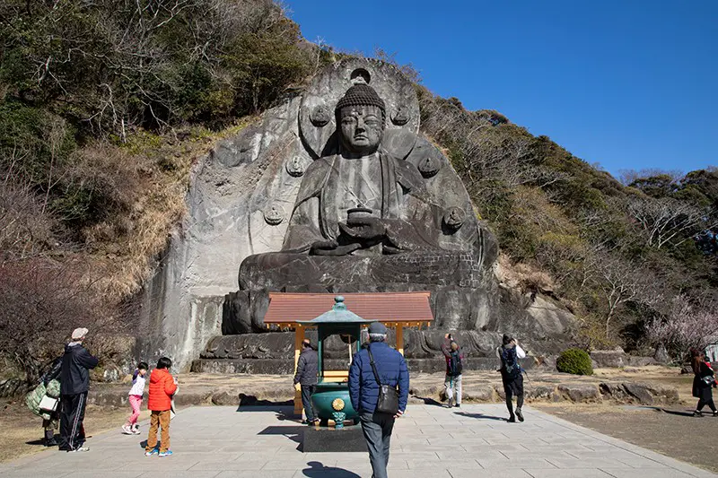
Nokogiriyama (Mount Nokogiri 鋸山) is a popular destination for people who live on the crowded Kanto Plain. It can get tiring slapping pavement every day, so Tokyoites love to get some fresh air and climb a mountain. With two large Buddhas and several thousand rakan (miniature carved monks and other religious persons), this area attracts pilgrims and outdoors people alike.
When you arrive in Nokogiriyama, you have the choice to drive, take a ropeway, or hike to the top of the mountain. Hiking is one huge concrete staircase, and there are more hiking paths at the end of the ropeway. Taking the ropeway up provides a unique view of Tokyo Bay.
At the top at 330 meters (1,083 feet), you can choose from many paths. Most are short, about 40-50 minutes long. The longest one takes you past all of the major sights. It takes about 90 minutes to complete and up to 2 hours with photo spots.
The routes vary in accessibility. Most of the walkway is either paved or a flat dirt path, but there are still plenty of cement stairs, rock stairs, and roots that can get in your way. Other than the stairs, it’s not difficult but can get slippery in the rain.
Along the path, there are some religious sites to visit. There is a big Buddha (Ishidaibutsu), the unbelievable Hyakushaku Kannon, and of course the many rakan along the path. These rakan are usually in a sitting position but may have different facial expressions. These sites make the walk that much more interesting, but it’s a gorgeous mountain by itself.
Extra tip: Take the Mount Nokogiri ropeway or gondola to the top of the mountain, then hike around there, especially if you have bad knees or have trouble with stairs.
How to Get There: Take the train to Hamakanaya Station. Or, rent a car and drive.
Admission Cost: Access to the trail is free.
- The Mount Nokogiri ropeway costs 500 yen ($4.60) one-way or 950 yen ($8.70) round-trip for adults and children 12 years and up, and 250 yen ($2.30) one-way or 450 yen ($4.15) round-trip for children 6 to 11 years old.
- Car parking is available at the top of the mountain for a small fee.
Mount Nokogiri is a fantastic day hike in Japan to visit. Photo credit: Reflections Enroute
Hiking in Japan: Chubu Region
Chubu Region, located in central Japan, is between Kanto and Kansai region. It’s a mountainous area so you’ll get some incredible hikes off the Japanese Alps. Here, we’re going hiking in Toyama, Nagano, and Gifu.
3. Mount Tate
Hiked by Cecilie, Worldwide Walkers
Location: Tateyama, Toyama Prefecture
Round Trip Distance: Approximately 6 kilometers (3.7 miles)
Duration: 3 hours round trip
Difficulty: Challenging
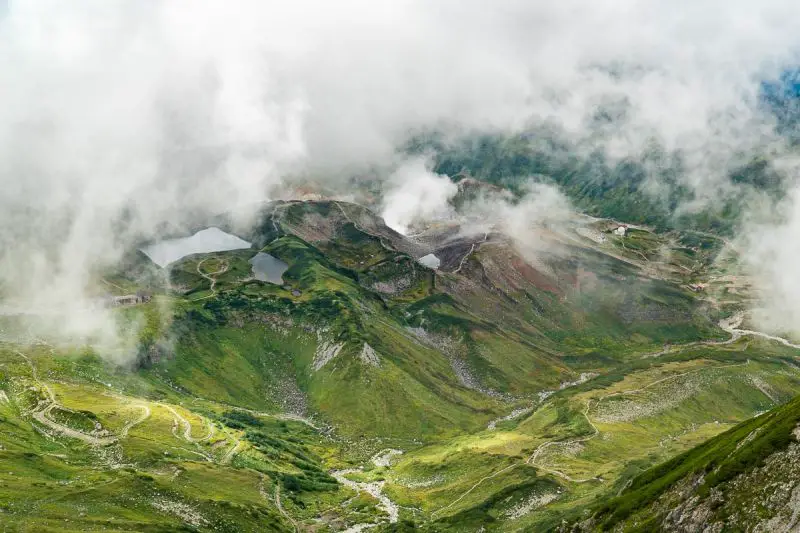
Mount Tate (立山) is one of the best day hikes you can do in Japan. The hike will take you into the clouds to the incredible 3,015 meters (9,892 feet) high mountain peak.
During the hike, you’ll get the most amazing views over Toyama City and the Japanese sea on one side, and the incredible Hida mountain range on the other.
Getting to the trailhead isn’t easy, and it requires a great deal of patience because you have to take several forms of transportation. However, once you get there, you’ll realize that it’s completely worth the effort.
The first part of the hiking trail is easy, but after about 40 minutes the clearly marked trail turns into a steep challenging climb to the top of the peak. Once you reach the peak, you can rest your tired legs and enjoy a packed lunch with some amazing mountain views or go explore a Japanese shrine. You return the same way you came from.
Apart from being one of the best and most beautiful day hikes in Japan, the mountainous area around Mount Tate also has a lot to offer such as hot springs and waterfalls. If you’re lucky, you might even be able to spot the Ptarmigan, which is a rare bird that survived the ice age.
How to Get There: It takes almost 3 hours to get to the trailhead at Murodo Alpine Station from Toyama City. You need to take public transportation, which includes a train, a cable car, and a bus. You can buy your return tickets at Toyama-Dentetsu Station.
Admission Cost: Access to the trail is free, but the transportation costs almost 7,000 yen ($64.20) for one return ticket.
Enjoy the stunning landscape views from Mount Tate’s summit. It’s truly one of the best places to go hiking in Japan! Photo credit: Worldwide Walkers
4. Kamikochi National Park
Hiked by Louise, A Free Drink
Location: Kamikochi National Park, Nagano Prefecture
Round Trip Distance: From 4 kilometers (2.5 miles) and up
Duration: A full day with breaks
Difficulty: Easy
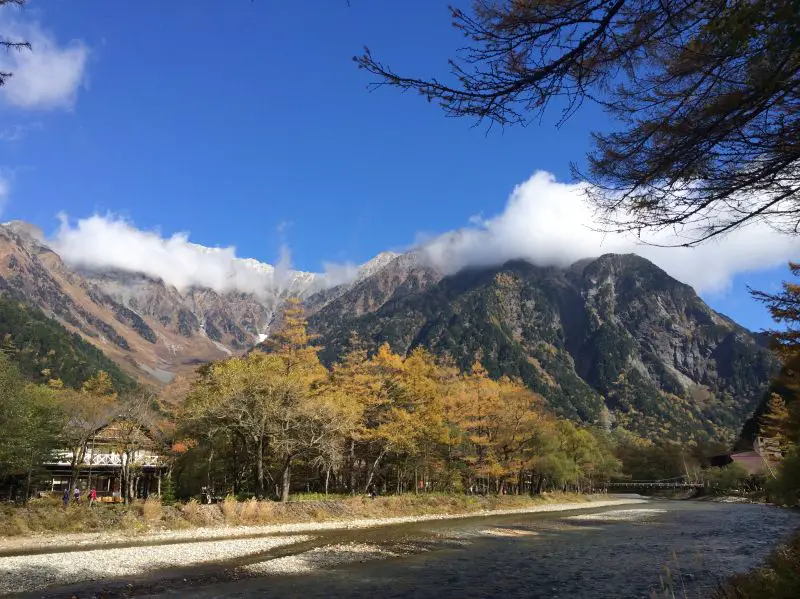
Kamikochi National Park (上高地) in Nagano Prefecture is most usually visited as a day trip, although overnight stays are possible in the several ryokans, hotels, and mountain huts in the park. Travel here by a combined bus and train ticket from nearby Matsumoto.
There are hiking trails for all abilities here and loops that you can connect to take longer hikes. You do not need a guide to hike here. There are maps available of the trails at the Visitor Center when you arrive and the staff speaks excellent English. Therefore, anyone can hike here and enjoy the easy terrain. Check out the shorter hiking trails here.
There is a river in the center of the valley and the main trails criss-cross the river, so use the bridges to cross. As you wander through the trails, there are spectacular viewpoints across the valley. Small cafes are available here and also shelter if you wish to take your own food and drink.
This is a “pack it in, pack it out” park though, so be sure to take all your garbage back to your hotel with you as there are no trash bins here.
How to Get There: To get to Kamikochi National Park, take a direct bus to Kamikochi from Tokyo, Osaka, and Nagano. Or, take the train to Shin-Shimashima Station in Matsumoto and then take the bus to Kamikochi. More information is here.
Admission Cost: The National Park is free to enter. You’ll need to pay for accommodations if doing multi-day trekking.
Kamikochi National Park is a great hiking spot in Japan since there are many hiking trails to explore. Photo credit: A Free Drink
5. Magome to Tsumago Trail via Nakasendo Trail
Hiked by Sarah of A SocialNomad
Location: Kiso Valley, Nagano Prefecture
One-Way Distance: 8 kilometers (5 miles)
Duration: 2.5 hours one-way
Difficulty: Easy – Moderate
The trail from Magome to Tsumago (馬籠 to 妻籠) is an 8 kilometer stretch of the 534 kilometers (332 miles) long Nakasendo Trail, which links Tokyo and Kyoto using the old “post town” route.
This is one of Japan’s most popular day hikes, although you’re unlikely to find many people on the trail. Most visitors will do this as a one-way trail and then take a bus and train back to their hotel. Magome and Tsumago have fantastic ryokan options, although many will stay in Nagoya too.
Tip: There is a paid-for bag transport service (in the direction of Magome to Tsumago only) if you don’t want to carry larger bags or backpacks.
You will not need a guide as the trail is well signposted. Also, the hiking is moderate on well-made trails. This is, however, the foothills of the Japanese Alps, so dress accordingly for the time of year and the weather, there is often snow in January and February.
The towns that bracket this part of the trail, Magome and Tsumago are pretty, photogenic ancient post towns with welcoming tourist agencies.
How to Get There: Japan Rail trains make this journey very easy. The nearest train station is Nakatsugawa Station and you can take the 30-minute bus to Magome.
Admission Cost: Access to the trail is free.
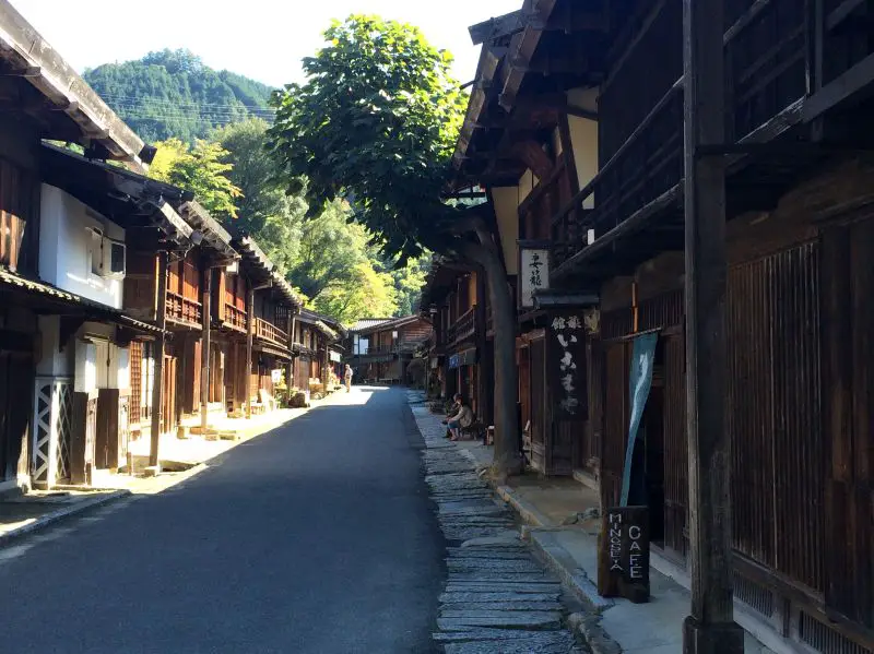
Check out the towns when hiking the Magome to Tsumago Trail. Photo credit: A SocialNomad
6. Shirakawa-go Village
Hiked by Noel, This Hawaii Life
Location: Shirakawa, Gifu Prefecture
Round Trip Distance: 1-2+ miles
Duration: A couple of hours
Difficulty: Easy – Moderate
One of the most beautiful hikes to do is in the alpine country at Shirakawa-go (白川村). It’s a UNESCO heritage cultural site where this beautiful village is made with thick layers of grass materials on the roof in a steep pitch to avoid the harsh and cold winter season in the region.
The area around this historic village is mountainous and forested and there are many trails with signage that you can take around the village and outlying areas.
There is a fantastic trail at the edge of the village with signage that takes you on a loop route above the village and into the hills with nice viewpoints, small temples, and overlook areas with benches to enjoy the views. Since it is mostly uphill on dirt trails, it’s a moderate hike on steady inclined paths that travel around 1-2 miles depending on how far you want to continue along the path areas or take another route back down to the village.
For something less challenging, take an easy walk around the village and stop by many of the living museum homes for a fun way to enjoy a tour of this beautiful community.
How to Get There: Getting to Shirikawa-go is only accessible by a combination of train and public transport commute bus that stops over the village. Take the train to Toyama, Kanazawa, or Shin-Takaoka Station and then take the bus.
You can break up your trip and take the bus the next day going from the main city at Takayama to the large port city at Kanazawa on the west coast of Japan.
Admission Cost: Access to the trail is free.
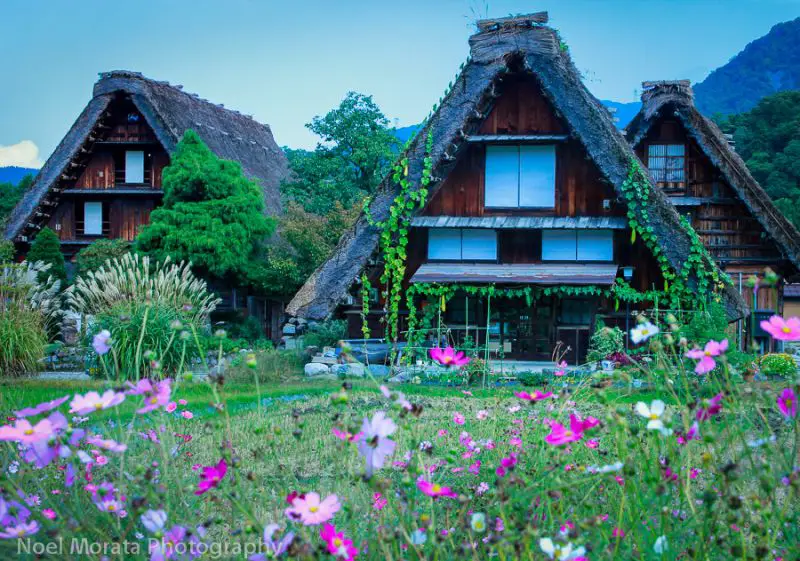
Wander through Shirakawa-go’s hiking trails to explore the historic village and area. Photo credit: This Hawaii Life
Hiking in Japan: Kansai Region
Kansai is located in the south-central part of Honshu Island. It’s a historical and cultural area with popular sites at Kyoto, Osaka, Nara, and Kobe. Here, we’re exploring Kansai’s hiking trails in Wakayama, Nara, Himeji, and Kobe City.
7. Kumano Kodo Pilgrimage Trail
Hiked by Katie and Ben, Two Wandering Soles
Location: Kii Peninsula, Wakayama Prefecture
Round Trip Distance: This is point A to point B trail, and hikers start and finish at two different locations. The length is between 50-70 kilometers (31-43.5 miles), depending on which route you take. Alternatively, it’s possible to hike just a portion of the traill.
Duration: 4-5 Days
Difficulty: Moderate
If you’re looking to have an off-the-beaten-path experience in Japan, hiking the Kumano Kodo (熊野古道) is an experience you should add to your itinerary. This Pilgrimage Trail boasts UNESCO World Heritage status and winds through the mountains of Japan’s Kii Peninsula.
Hikers will make their way through thick forests and quaint countryside villages on a magical multi-day trek. During the day, walk past centuries-old cedar trees, historic relics, temples, shrines, and viewpoints.
At night, those on the trail can seek refuge in guesthouses and homestays. Rest your feet and indulge in a traditional meal made with local ingredients such as fish from the river past which you hiked and vegetables from nearby farms. Most inns also have onsite onsens, which is the perfect way to relax weary muscles.
The trail culminates at the Nachi Taisha Shrine, an iconic symbol of the trail and one of the most beautiful shrines in the country. Standing in its presence is the perfect way to celebrate completing the trek.
Embarking on the Kumano Kodo requires a good deal of planning and booking guesthouses along the way, but it’s well worth the effort and will likely be one of your highlights on your trip to Japan.
How to Get There: While there are several places to start this trail, each trailhead is accessible by bus. The most common starting point is near Tanabe Station.
Admission Cost: Access to the trail is free, however, you’ll need to pay for accommodation and food along the way.
Kumano Kodo is an epic multi-day trek in Japan to add to your itinerary. Photo credit: Two Wandering Soles
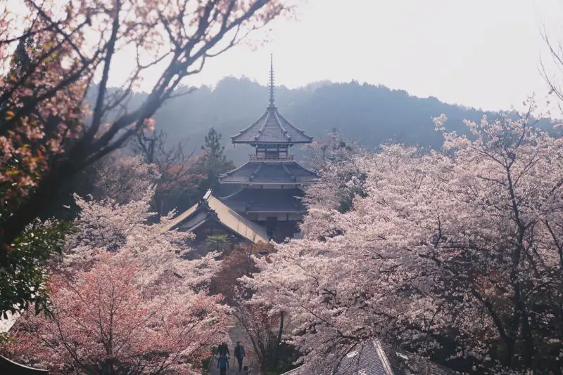
8. Mount Yoshino
Hiked by Jacqueline, Your Travel Flamingo
Location: Yoshino, Nara Prefecture
Round Trip Distance: Unknown
Duration: 80+ minutes round trip
Difficulty: Easy
Most first-timers in Japan may not know of Mount Yoshino (吉野山), but for locals, the beauty of this mountain is no secret. It’s famous as being one of the best cherry blossom viewing spots in the country, a title it’s held onto for centuries. Seeing this place during cherry blossom season is a major bucket list experience, however, a hike up Mount Yoshino is honestly beautiful any time of year.
Hike the entire route will take you about 40 minutes to reach the Kami Senbon area, which is considered the peak of the hike.
Once you reach the peak of Mount Yoshino at 350 meters (1,150 feet), you’ll have sweeping views of the mountains below. During cherry blossom season, the mountains are covered in various shades of pink. In autumn, the mountain is ablaze with red and orange, from the fall foliage.
Mount Yoshino is also home to some beautiful temples, the most significant ones being Kinpusenji Temple and Yoshimizu Temple.
Around this area, is also a historic little village center. You should stop by the village on your way down from your hike, and grab some Japanese soba or a snack at one of the restaurants. These are built in traditional Japanese style, and often without windows. Since they’re right on the edge of the mountain, they offer grand views of the mountains below, which are simply stunning, especially when covered in cherry blossom trees.
How to Get There: The closest train station is Kintetsu Yoshino Station. From there you can either begin the hike up the mountain on foot, or opt to take the ropeway to the midpoint and hike from there.
Admission Cost: Access to the trail is free.
- The Mt. Yoshino ropeway costs 450 yen ($4.15) one-way or 800 yen ($7.40) round-trip for adults and 230 yen ($2.10) one-way or 400 yen ($3.70) round-trip for children (4 years old to elementary school students).
Mount Yoshino is a top hiking spot in Japan to see gorgeous cherry blossoms during the springtime. Photo credit: Your Travel Flamingo
9. Mount Shosha
Hiked by Mia, Walk a While With Me
Location: Himeji, Hyogo Prefecture
Round Trip Distance: Unknown
Duration: It takes around 45 minutes to climb Mount Shosha one-way, but you should spend at least a couple of hours exploring the enchanting Engyo-ji Temple at the summit.
Difficulty: Beginner
One of the best things you can do in Himeji is to climb up Mount Shosha (書写山). A small mountain at 371 meters (1,217 feet) high is most commonly accessed by Mount Shosha ropeway. There is a fee for the ropeway. So, if you’re a budget traveler or simply love to hike, then taking the trail up Mount Shosha is the better option!
A short and easy hike, the climb up Mount Shosha provides lovely views of Himeji City. But, the best part of climbing up Mount Shosha is exploring the Engyo-ji Temple at the summit.
An ancient and serene temple complex, the history of Engyo-ji Temple spans 1,000 years. Truly, exploring its vast grounds makes you feel like you’ve traveled back in time. A popular filming location (mainly for domestic films, but also the filming location of The Last Samurai), the Engyo-ji Temple complex is spread over Mount Shosha’s summit, so you can easily spend hours wandering around the charming forests and admiring the ancient buildings!
Overall, while Mount Shosha is an easy hike, the Engyo-ji Temple is an unmissable attraction on your trip to Himeji. So, if you want to explore the enchanting woods of an ancient temple untouched by the modern world, climb Mount Shosha!
How to Get There: From Himeji Station, take the number 8 bus to the Mount Shosha Ropeway. This will take around 25 minutes. From the Mount Shosha Ropeway, you can find several signs near the parking lot that will lead you to the trail head. It’ll take around 5-10 minutes to walk to the trailhead and just follow the signs.
Admission Cost: Access to the trail is free.
- The Mount Shosha ropeway costs 600 yen ($5.50) one-way or 1,000 yen ($9.20) round-trip for adults and 300 yen ($2.80) one-way or 500 yen ($4.60) round-trip for children.
- To enter Engyo-ji Temple, it costs 500 yen ($4.60).
Capture these awesome views from Mount Shosha summit. Photo credit: Walk a While With Me
Read More: What to Do on a Himeji Day Trip
10. Mount Rokko
Hiked by Xin, Xinventure
Location: Kobe, Hyogo Prefecture
Round Trip Distance: 20 kilometers (12.4 miles)
Duration: 6+ hours round trip / 3-5 hours one-way
Difficulty: Challenging
If you’re in Kobe or Osaka indulging in your foodie fantasies, add Mount Rokko (六甲山) to your itinerary for a scenic and calorie-burning detour! This is one of the most popular and challenging hikes in the Kansai region, offering spectacular views of Kobe, Osaka, and the nearby mountains.
Finding the trailhead is a quick adventure in and of itself. The hike begins behind a shrine with a waterfall, and the initial portion is a steep climb on large rocks. You may need to use your hands. Ganbatte! The views begin immediately and eventually the hike levels out.
It will be a long and strenuous few hours. Remember to carry plenty of water and give yourself enough breaks. Also, make sure to dress for a 900 meters (2,953 feet) elevation gain.
Once you reach the top, especially if it is a cold day, reward yourself with a steaming bowl of udon at the teahouse. Then record your achievement by taking a photo with the “highest point 931 meters (3,055 feet)” elevation marker.
Instead of hiking back down the way you came, consider taking a fun cable car that brings you to the outskirts of Kobe. If you plan ahead, you can also continue onwards to Arima Onsen, a famous hot spring town with over 1000 years of history hidden behind Mt. Rokko.
How to Get There: Take the Hankyu Kobe Line to Ashiyagawa Station. Follow the signs for 六甲山 (“Rokkosan”). If you can’t find a sign, walk North along the river for a few minutes and wind through a residential area to find the shrine.
Admission Cost: Access to the trail is free.
- The Mount Rokko cable car costs 600 yen ($5.50) one-way or 1,100 yen ($10.10) round-trip for adults and 300 yen ($2.80) one-way or 550 yen ($5.05) round-trip for children (ages 6-12 years old).
- Taking the ropeway from Rokko Sancho Station to Arima Onsen Station costs 1,030 yen ($9.50) one-way or 1,850 yen ($17) round-trip for adults and 520 yen ($4.80) one-way or 930 yen ($8.60) round-trip for children.
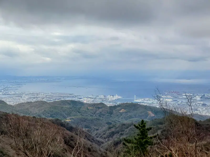
You’ll see some beautiful views from your Mount Rokko hike. Photo credit: Xinventure
Hiking in Japan: Chugoku Region
Located in the western region of Honshu Island, there are a couple of hikes worthy to explore. We’re off to Chugoku’s hiking trails in Tottori and Hiroshima.
11. Mount Mitoku
Hiked by Rhonda, Travel Yes Please
Location: Near Misasa, Tottori Prefecture
Round Trip Distance: 1.5 kilometers (.93 miles)
Duration: 1.5 hours round trip
Difficulty: Challenging
The hiking trail on Mount Mitoku (三徳山) is a spiritual route that visits several wooden buildings of Sanbutsu-ji Temple that are built on the mountainside at 900 meters (2,953 feet) high. The trail starts at the main hall of Sanbutsu-ji Temple then climbs up the forested mountain to Nageiredo Hall, which seems to defy gravity by hugging the cliff face.
The hike is challenging because it’s steep, requires navigating over a lot of exposed tree roots, and has a section where you have to climb up a wall of rock using a chain for support.
Conquering those difficult sections of trail is rewarded by a visit to Monjudo Hall, where you can sit on the narrow terrace and admire panoramic views of the surrounding hills.
Continuing up the mountain, the trail passes by more temple buildings and a large bell before arriving at its final destination, Nageiredo Hall. This architectural marvel will have you wondering how it has stayed put on this vertical cliff for over 1000 years.
Since this hike has some hazards, it’s a requirement to have hiking shoes with good grips and to travel in a group of two or more people.
How to Get There: The nearest train station is Kurayoshi Station in Kurayoshi and you take a bus. The bus travels through Misasa and you get off at the Mitokusan stop.
Admission Cost: To enter the temples, the admission is 1,200 yen ($11.00).
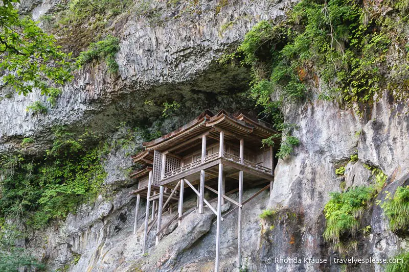
Hiking Mount Mitoku is well worth the effort to see temples built on the mountainside. Photo credit: Travel Yes Please
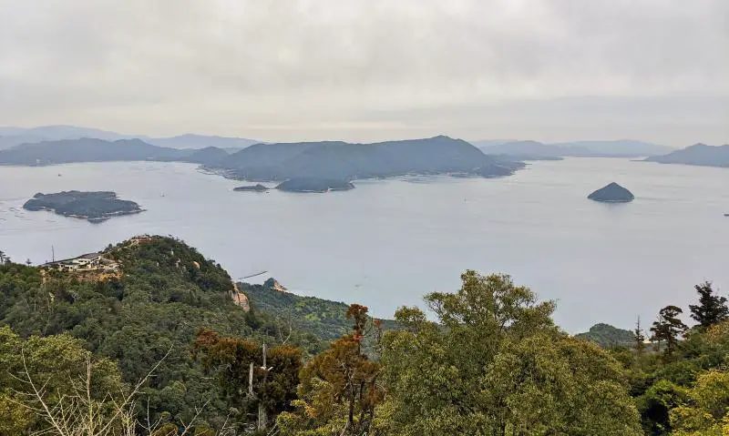
12. Mount Misen
Hiked by Editors, Jackie and Justin, Life Of Doing
Location: Miyajima Island, Hiroshima Prefecture
Round Trip Distance: 4.8 kilometers (3 miles)
Duration: 2+ hours
Difficulty: Moderate
Mount Misen (弥山) is a fantastic day hike to do in Japan. Located on Miyajima Island, it’s a fun day trip from Hiroshima. After exploring the iconic orange torii (called Otorii) off of Itsukushima Shrine, a UNESCO World Heritage Site, and other temples, head to Daishoin Temple area to hike up Mount Misen.
This moderate hike takes you through the forest area with large rocks as stairs. Some parts are a bit steep so take your time hiking up. The trail is mostly quiet as there are a handful of hikers along the way and most people take the ropeway up the mountain. Along the way, you’ll see adorable deer munching on grass and they may even pose to take a selfie photo with you.
Once you reach the summit at 535 meters (1,755 feet), head to the observation deck to take a rest. Here, there is free wifi and restrooms available. The observation deck has gorgeous views of the waters and the island. During the fall season, you can see the trees covered with fall-colored leaves. The summit also has an area of tall rocks and boulders to take photos with.
On the way down, you can take a quick detour and pass by sacred temples and pagodas, take the ropeway, or return the same as you came up.
Read More: What to Do on a Miyajima Day Trip
How to Get There: Once on the island, head to the Daishoin Temple. Before entering the temple grounds, you’ll see the Daishoin trail to the left side. Follow this path to reach Mount Misen’s summit. Or, take the Omoto course which is to the west of Daishoin Temple.
Admission Cost: Free to access the trail.
- If you want to take the Miyajima Ropeway, the cost is 1,010 yen ($9.30) one-way or 1,840 yen ($16.90) round-trip for adults and 510 yen ($4.70) one-way or 920 yen ($8.45) round-trip for children (6-12 years old)
Hike Mount Misen during your day on Miyajima Island.
Final Thoughts
How many of these Japan hiking trails are now on your bucket list? With so many trails to experience, you’ll want to visit Japan a few times to conquer all of them! One or more of these trails would be a fantastic addition to a future Japan itinerary.
Happy hiking!
Want to refer to this post later? Save it to your Japan Pinterest board!
Featured photo credit: sepavone via Depositphotos.com