
Looking for a healthy and adventurous activity to do in Vietnam? Let’s head to a hiking trail to get some fresh air, burn calories, escape the loud city noise, and explore the outdoors!
Whether you’re traveling or living in North, Central, or South Vietnam, there are plenty of day hikes and longer trekking routes for you to experience.
Not sure where to go hiking in Vietnam? It’s not a problem!
In this post, we’re sharing the 14 best hikes in Vietnam including day and multi-day hikes, where they’re located, and important information about the trails such as admission cost and difficulty levels.
Although this isn’t a comprehensive list of all the hiking trails in the country, these are the trails that we’ve personally visited after spending over 4+ years living in Ho Chi Minh City (Saigon). Therefore, you’re getting an insider view of what to expect with these hikes.
As a heads up, some of the hiking and trekking trails require a tour guide due to the safety and the remoteness of the trail location.
If hiking isn’t enough to visit this country, check out other fantastic reasons to travel to Vietnam.
Now, let’s go hiking and explore a unique side of Vietnam.
Click on the links below to jump to certain areas of this Vietnam hiking guide.
*Disclaimer: This post contains affiliate links. As an Amazon Associate, we earn from qualifying purchases. If you click on them and make a purchase, we receive a small commission. There is no additional cost to you. Appreciate the support.
What to Bring On Your Vietnam Hikes
Before you head out on a Vietnam hiking trail, you need to do some preparation. Here are some helpful tips and important gear that you’ll need for a hike.
- Use a backpack to hold your important stuff. If your backpack has shoulders and hip belts, it’ll help shift the weight of your backpack when you’ve been hiking for hours. Our favorite backpacks are here: men and women versions.
- Stay hydrated and bring a reusable water bottle. Many of the trails are in remote places, so there aren’t any convenience stores to purchase water. Continue to drink lots of water on the trail and use a reusable water bottle to lessen plastic waste.
- Wear proper hiking boots or shoes. Some of the trails require hiking boots due to the changes in terrain. By having the proper footwear, you can walk for hours comfortably. It wouldn’t be fun to receive hot spots or blisters! We love these men hiking boots or women’s hiking boots. If you’re not into wearing heavy boots, these hiking minimalist shoes will be an excellent option for easier hiking routes.
- Wear a hat and sunscreen. It can get brutally hot in the sun, so it’s necessary to wear a hat and sunscreen.
- Hiking poles are optional. If you have knee issues or will climb a steep mountain, hiking poles will be helpful.
- Bring your trash home and leave no trace behind. Let’s continue to keep Vietnam’s mountains clean for future generations. Bring all trash with you.
Map of Where to Go Hiking in Vietnam
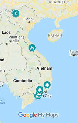
Click on the image to see a larger view of where the Vietnam hiking trails are located. Credit: Map data: Google
Hiking in North Vietnam
Northern Vietnam has some of the best hiking due to its mountainous range. Head to Hanoi and start your hiking and trekking adventure from there.
1. Mount Fansipan
Location: Hoang Lien National Park, Sapa
Distance: 14 miles (22.5 kilometers) round trip | Duration: 1 or 2 days | Difficulty: Challenging
At the highest peak in Vietnam at 3,143 meters (10,312 feet), Mount Fansipan (Phan Xi Păng in Vietnamese) is one of the toughest hikes in Vietnam to conquer. The summit is known as the “Roof of Indochina” since it’s the tallest peak in Indochina (Vietnam, Laos, and Cambodia).
To get to the summit, most hikers take the Tram Tom route. You can’t miss the start since you’ll need to register at the Ranger’s station before hiking. Once you start hiking, you walk through the forest area with trees, running streams, and wildflowers blooming around you. The trail requires some scrambling up huge boulders and stairways so you’ll need to be in physical strength.
Once you’re at the top, you can explore the newly branded Sun World’s Fansipan Legend. The must-visit spot is to take a photo with the Fansipan 3,143 meters signs. You have to show off your accomplishments! There are also temples, Buddha statues, and other fun attractions to visit.
Climb Fansipan in 1 day is for the true hardcore hikers and will be challenging. It’ll take 6-12+ hours to complete depending on the speed and number of rest breaks. The more leisure route is to take 2 days with an overnight stay at a camping site or indoor shelter. Or, you can hike up one way and take the cable car down, although, you will pay for a round-trip cable car ticket.
Hiring a tour guide is necessary. There are many spots along the trail where you can veer off and get lost. Plus, the tour guide can help with registering you at the Ranger’s Station. We used Zaazaa Trekking for our tour.
Adding this Fansipan hike to your future Sapa itinerary would be a fantastic addition. Before you go, check out our Sapa trekking tips.
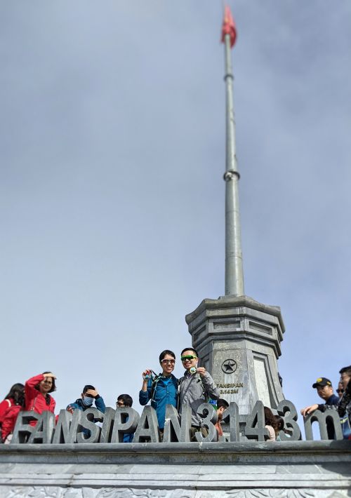
Mount Fansipan is one of Vietnam’s bucket list hikes to complete.
How to Get There: Your Fansipan tour will include taxi transportation to the Tram Tom starting spot where the Ranger station is located. Find “Núi Xẻ Ranger Station Trạm Tôn” in Google Maps.
Admission Cost: A Fansipan trekking tour will vary depending on whether it’s a 1 or 2 day trip. For 1 day, expect to pay $60-$80 USD per person. (The Sapa treks are quoted in US Dollars and paid in Vietnamese currency).
2. Muong Hoa Valley’s Lao Chai and Ta Van Village
Location: Sapa
Distance: 6–7 miles (9.6-11 kilometers) per day | Duration: 1 or 2 Days | Difficulty: Easy-Moderate
Sapa, located in the Lao Cai Province, is a beautiful place to hike in Vietnam. Many trekkers flock to this area to see the golden rice terraces and wander through the ethnic minority villages where the Hmong, Dao, Xa Pho, Tay, and Day people live. Since there are many hiking routes to experience in Sapa, Muong Hoa Valley’s Lao Chai and Ta Van Valley is a fantastic trek in Vietnam for beginners.
The trek is mostly flat with some inclines up a hill. The technical parts are going down a muddy, slippery path through the rice terraces and forest areas. Otherwise, many parts of the trail are along a paved path.
Depending on how much time you have in Sapa, you can visit Lao Chai and Ta Van from Sapa as a day trip or over two days. We hiked for two days to have more time to wander through the villages and not feel rushed trying to finish in one day. One of the main highlights was the opportunity to stay overnight and have dinner with the local family at a homestay.
A trekking guide is necessary to help navigate through the area and we used Zaazaa Trekking (as mentioned above for Fansipan).
Other popular areas to trek are Cat Cat Village to Y Linh Ho, Sa Sen to Hau Thao, and Ma Tra to Ta Phin Village.
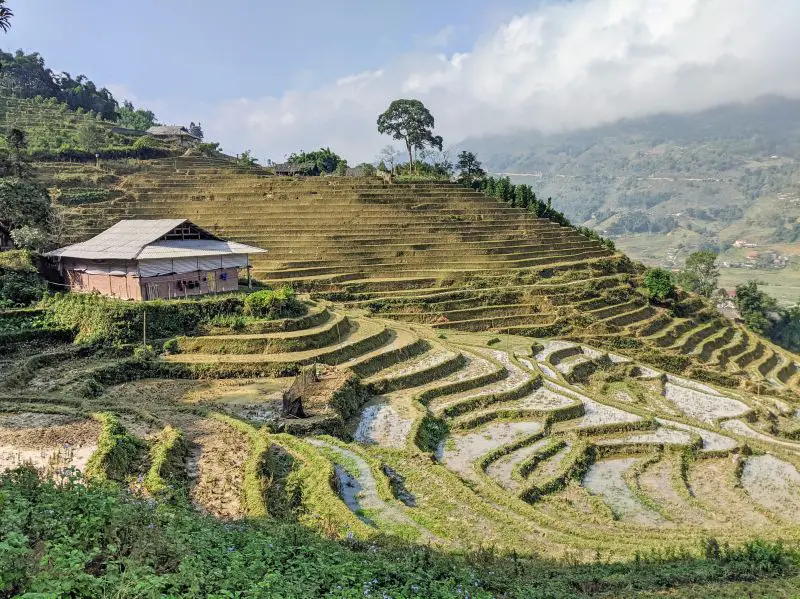
Hike through Vietnam’s rice terraces in the Sapa area
How to Get There: From Sapa town, your guide will lead you to the villages.
Admission: The average cost for a 2-day tour is $60 per person.
Related: How to travel from Hanoi to Sapa
3. Me Pia Pass
Location: Along Highway 4A, Cao Bang Province
Distance: 2 kilometers (1.2 miles) round trip | Duration: 50 minutes – 1 hour round trip | Difficulty: Moderate
One of the hidden gems of Cao Bang is visiting Me Pia Pass (Đèo Mẻ Pia). It’s a windy road along Highway 4A that has 14 sharp turns (also known as 14 passes).
Driving along this road is an adrenaline rush and scary. Yet, the coolest experience is doing a short hike to see the road from above. The hike is short yet it does have large boulders and some steep parts to climb up.
Once you reach the viewpoint, you’re rewarded with an unobstructed and jaw-dropping view of the road (which looks like a slithering snake).
It’s worth the drive to get here and to experience this view yourself.
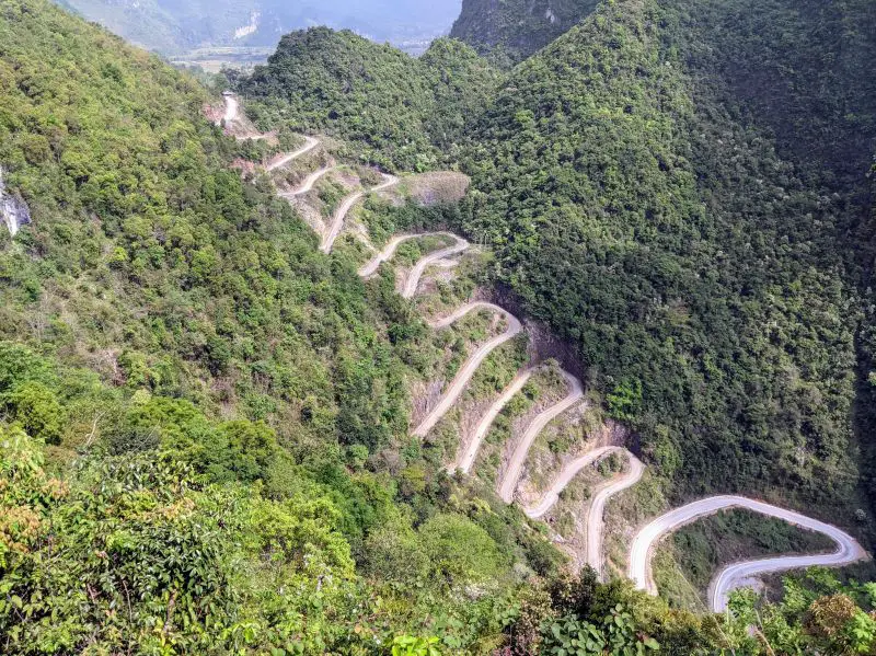
A short hike is required to see this incredible view of Me Pia Pass.
How to Get There: Whether you’re coming from Ha Giang or Cao Bang city center, expect to take around 3-3.5 hours along Highway 4A. There is a rest stop at the top of the 14-passes. Cross the street and follow the red arrows.
Admission Cost: Free
Hiking in Central Vietnam
Central Vietnam is known for the coastal beaches and relaxation, yet there are some incredible hikes to conquer.
4. Hang En Cave
Location: Phong Nha Ke Bang National Park, Phong Nha
Distance: 5.5-6.5 miles (3.4-6.5 kilometers) per day + caving on the second day | Duration: 2 Days | Difficulty: Easy-Moderate
Phong Nha is the “Adventure Capital of the World” and is known to have hundreds of limestone caves to explore. One of the best caves to visit is Hang En Cave (Hang Én), located in the Phong Nha Ke Bang National Park. It’s famous for being the world’s third-largest cave, while its big sister, Son Doong (Sơn Đoòng), which is only 1.2 miles (2 kilometers) from Hang En, is the world’s largest cave.
This 2-day trekking tour, offered by Oxalis Adventures, takes you through the forest area of the National Park and through a small village to get to this hidden cave. Oxalis is the only tour agency that has access to this cave so you and your small group (up to 16 people) have the whole cave to yourself.
The out-and-back hiking trail is great for beginners as you can take as much time as needed to hike. There are plenty of breaks during the hike. Plus, there are at least two guides and two Support Team members to assist trekkers with sketchy downhill areas or crossing rushing rivers.
Once you get to the off the beaten path cave, you’ll see how massive this cave is. You’ll see how long the cave stretches on your second day during the caving exploration.
A cool and memorable experience about this Hang En trek is that you get to sleep overnight in the cave and may get the chance to see a gorgeous sunbeam enter the cave in the morning.
After the Hang En hike, explore other fun areas of Phong Nha and consider taking a side trip to Bong Lai Valley.
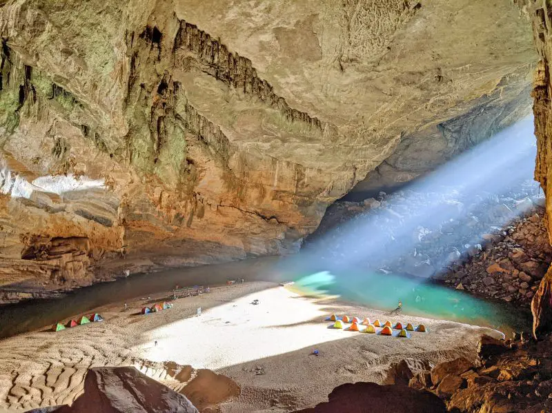
Hang En Cave is one of the coolest treks in Vietnam to complete. Check out the gorgeous sunbeam that we experienced!!
How to Get There: All hikers will meet at the Oxalis Headquarters in Phong Nha town and will take a bus to the start of the trek.
Admission Cost: The tour costs 7,600,000 VND ($330) per person.
Hiking in South Vietnam
Many of the hikes in South Vietnam require some mode of transportation whether you’re based in Ho Chi Minh City or Dalat. Regardless, the consistent weather throughout the year makes it an awesome opportunity to explore the trails.
5. Dinh Mountain
Location: Close to Vung Tau, Ba Ria-Vung Tau Province
Distance: 4-8+ miles (6.4-12.8 kilometers) | Duration: 3-5+ hours | Difficulty: Easy-Moderate
Dinh Mountain (Núi Dinh) is a popular day hike from Ho Chi Minh City and close to the beach area, Vung Tau. Many trail runners and hikers travel around the mountain to get to the summit at 460 meters (1,500 feet high).
The summit doesn’t have a summit sign, yet it’s on a giant rock where you’re rewarded with a panoramic view of the Vung Tau area.
The hiking isn’t too difficult yet there are some hills to climb. Luckily, the trail is mostly shaded so you can take your time going up the mountain. Hikers can make a loop around the mountain or do an out-and-back route to the summit.
Unfortunately, the trail doesn’t have good signage, yet there are red, yellow, and blue markers to follow. Otherwise, it’s recommended to bring a friend who knows the route. Along the way, you’ll pass by a few temples and locals living in the area.
Depending on your time of visit, Dinh Mountain has several waterfalls for you to swim in. The rainy season from April to October and there will be larger cascades. Life jackets are available for safety.
Add Dinh Mountain to your Vietnam hiking list when visiting Ho Chi Minh or Vung Tau.
How to Get to There: Take a motorbike or hire a driver to different parking lots:
- “Suối Ðá” or “G49C+C6 Tân Hải, Bà Rịa–Vũng Tàu, Tân Thành, Ba Ria – Vung Tau, Vietnam,” or
- Đường Xe Lên Núi Dinh, Kim Dinh, Tân Thành, Bà Rịa – Vũng Tàu, Vietnam” (the main parking lot)
You can find these in Google Maps for the exact pinpoint. From Ho Chi Minh City, it’ll take at least 2 hours one-way. From Vung Tau, it’ll take 25 minutes one-way.
Admission Cost: Free. There is a small fee for parking and to go to the waterfalls.
6. Chua Chan Mountain
Location: Xuan Loc District, Dong Nai Province
Distance: 4.6 miles (7.5 kilometers) | Duration: 3+ hours | Difficulty: Easy-Moderate
Chua Chan Mountain (Núi Chứa Chan) is a unique day hike in South Vietnam to experience. Located in Dong Nai Province, a 2-hour drive outside of Ho Chi Minh City, it’s an opportunity to climb 837 meters high (2,746 feet) to reach the peak.
The out-and-back hiking path is easy to follow so a tour guide isn’t necessary. The first half of the hike is a leg burner as you climb up a paved set of stairs. This path is covered so it’ll shield you from the mid-morning sunshine. It’s the second highest peak in South Vietnam.
Along the way, you’ll pass by vendors selling foods and snacks as offerings to the pagodas. Try fried banana chips as an energy-boosting snack.
Or, you can stop by one of the shops for a snack break such as bánh xèo (Vietnamese sizzling pancakes).
Once you pass the pagoda, follow the dirt path to go to the summit. This part is a bit more challenging due to the incline, but it’s not technical.
At the summit, take a photo with the triangle summit sign. On a clear day, you’ll see the landscape views of the Dong Nai area.
If you don’t want to head back down the mountain, you can take a cable car from the pagoda area to the bottom of the hill. Since you’re already heading down, you might as well finish walking down the paved set of stairs!
Chua Chan Mountain is a fantastic day hike in Vietnam!
How to Get to There: Take a motorbike or hire a driver to go to “Khu Du Lịch Cáp Treo Núi Chứa Chan, Xuân Trường, Xuân Lộc, Đồng Nai, Vietnam” in Google Maps. From Ho Chi Minh City, it’ll take at least 2 hours to get to the parking lot. You can also take a local bus from Ho Chi Minh City.
Admission Cost: 14,000 VND ($.60 USD) for adults, 6,000 VND ($.26 USD) for children ages 6-15 years
7. Cat Tien National Park
Location: Nam Cat Tien, Dong Nai Province
Distance: Varies | Duration: 1 or 2 Days | Difficulty: Easy-Moderate
Cat Tien National Park (Vườn Quốc Gia Cát Tiên) is a perfect place to go on a nature hike from Ho Chi Minh City or Dalat. It’s a quiet National Park and surrounded by wildlife and trees. You can’t go wrong with wandering around the walking paths to see where you end up.
There are two hiking trails to try at Cat Tien National Park –
1. Hike through the forest area to see the giant Tung Trees and Uncle Dong redwood tree. It’s about 2 miles (3.2 kilometers) away from the Visitor Center. The trail is easy to do since it’s very flat and isn’t technical. Therefore, a tour guide isn’t necessary for this walk. As long as you follow the walking path, you can’t get lost. As a heads up, there are lots of overgrown plants along the trail.
2. Hike to Crocodile Lake which is 17 miles (28 kilometers) round trip. To get to Crocodile Lake, you’ll need to take a car or bicycle to the starting point which is 5.6 miles (9 kilometers) away from the Visitor Center, and then you walk an additional 3.2 miles (5 kilometers) to reach the lake. If you don’t want to do this entire route in one day, you can stay overnight at the Ranger’s Station with advance notice. Tours are arranged through the National Park.
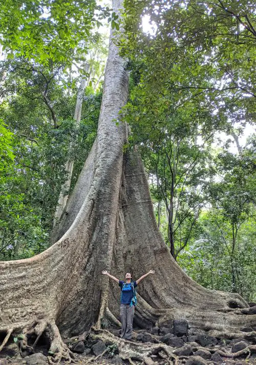
Here is the impressive Tung Tree along the Cat Tien National Park hiking trail.
How to Get There: Ride a motorbike or hire a driver to go to Cat Tien. Local buses are also available from Ho Chi Minh City. Allocate a minimum of 3.5-4 hours to get to the park from Ho Chi Minh City.
Admission Cost: If you hike through the forest area, it’s included in the National Park fee. It is 60,000 VND ($2.60) for adults and 10,000 VND ($.43) for children ages 6-16 years. The Crocodile Lake tour is 140,000 VND ($6.10).
8. Bidoup Nui Ba National Park
Location: Lac Duong District, Lam Dong Province
Distance: 17.3 miles (28 kilometers) round-trip | Duration: 2 Days | Difficulty: Moderate-Challenging
Bidoup Nui Ba National Park (Vườn quốc gia Bidoup Núi Bà) is rarely mentioned as a hiking trail in Vietnam to experience. Due to its remote location, it’s not as popular compared to the Lang Biang Mountain in the Dalat’s Central Highlands area.
If you get the chance to check out Bidoup, we recommend it! The National Park is quiet and rarely has visitors. You get the chance to walk through the forest without any disturbance and reach the summit at 2,287 meters (7,503 feet). Unfortunately, the summit doesn’t have the photogenic panoramic views of the area as it’s in the middle of the forest. However, you get to take a photo with the triangle-shaped summit sign.
The hiking is more challenging than other hikes in South Vietnam, which is why you need to join a tour group for 2 days with 1 night at a campsite. We did the tour with Tổ Ong Adventure and had a support team with guides, chefs, and porters.
After visiting Bidoup Nui Ba National Park, spend at least 3 days hanging out in Dalat.

Bidoup Nui Ba National Park is an underrated place to go hiking in Vietnam.
How to Get There: Head to Dalat from your departure city. Your tour company will take you to the starting point from Dalat.
Admission Cost: The tour starts at 3,290,000 VND ($143) per person.
9. Nui Lon Mountain (Big Mountain)
Location: Vung Tau, Ba Ria-Vung Tau Province
Distance: Various – up to 4.8 kilometers (3 miles) | Duration: 1.5 hours | Difficulty: Challenging
If you’re visiting Vung Tau and need a break from the beaches, consider hiking up Big Mountain (Núi Lớn). It’s the highest peak in the area with a summit of 245 meters (803 feet).
While the summit isn’t too high, the hiking trail is challenging! You must go with a local who knows the route since it’s not easy to navigate.
We followed a secret path off of Vi Ba Road that goes through the forest area and zigzags down the steep mountain. It’s STEEP since you can roll down the mountain with one fall or you need to grab onto any bamboo trees or branches to make your way down. There is scrambling up and down giant boulders involved too.
Once you stop at several vantage points to see the Vung Tau city and oceanside, it’s well worth the effort to hike this route. The views are stunning! You can even see the iconic Jesus statue on Small Mountain (Núi Nhỏ) from afar.
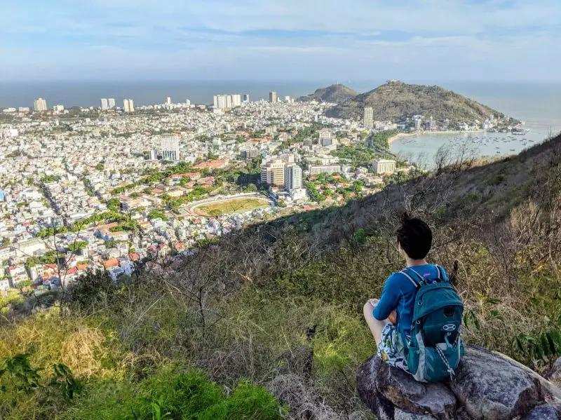
Hiking Big Mountain and seeing this view is worth the effort!
How to Get There: From Ho Chi Minh City to Vung Tau, allocate over 2 hours one-way by motorbike or hiring a driver. Mini-vans also drive directly to Vung Tau City, but you’ll need another mode of transportation to get to the hiking trail.
Admission Cost: Free
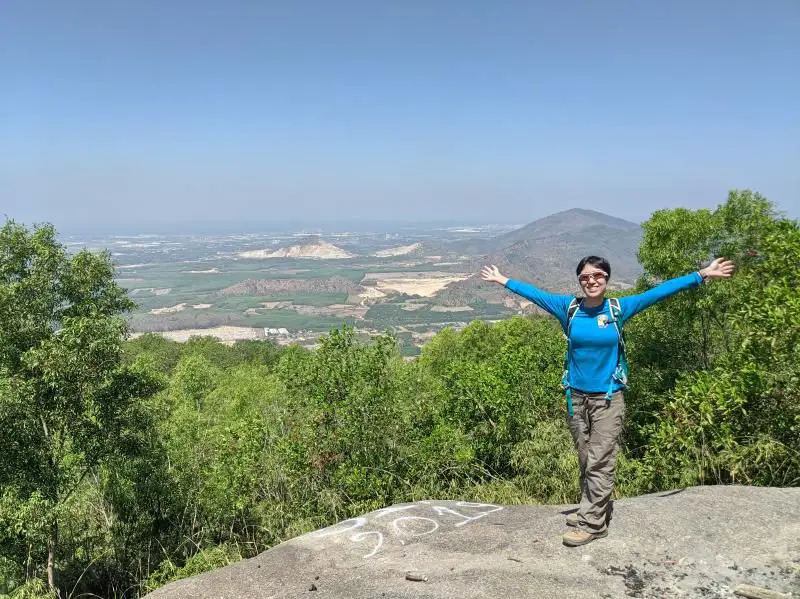
10. Ba Den Mountain (Black Virgin Mountain)
Location: Thanh Tan, Tay Ninh Province
Distance: 6.6 kilometers (4.11 miles) | Duration: 4+ hours round trip with breaks | Difficulty: Challenging
Hiking Ba Den Mountain (Núi Bà Đen, Black Virgin Mountain, or Old Lady Mountain) is a bucket list hike when you’re in Vietnam. It’s a popular day hike since it’s the highest summit in South Vietnam at 986 meters (3,235 feet).
There are 5+ hiking routes to reach the summit, and the “easier” yet super challenging way is via the electricity pole route. Prepare yourself by climbing up and down A LOT OF giant rocks and boulders.
Portions of the trail are very steep so take your time climbing up and include lots of rest stops. You must bring water on the trail as it gets HOT hiking in the daytime.
Once you reach the top, take a rest at the Sun World Ba Den tourist site and explore the area. There isn’t any additional fee to visit the theme park.
Check out the colorful plants and topiary on display and see the iconic black bronze Lady statue from afar. You can also take a photo with the triangle-shaped summit peak sign to show off your accomplishment!
You can take the same hiking route back down or take the cable car (but you’ll pay for a round-trip ticket).
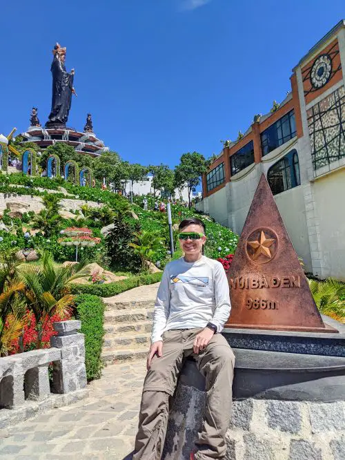
Don’t forget to take a photo with the Ba Den Mountain landmark.
How to Get There: From Ho Chi Minh City to Tay Ninh, hire a driver or ride a motorbike to the hiking route. There is a parking lot and it’s only a few minutes walk to the Electrical line trailhead which is next to the “Vạn Pháp Cung Pagoda.”
Admission Cost: Free
11. Ba Ra Mountain (White Virgin Mountain)
Location: Phuoc Long, Binh Phuoc Province
Distance: Various. 2- 7.2+ kilometers (1.2-4.5+ miles) | Duration: 2 hours | Difficulty: Easy-Moderate
Ba Ra Mountain (Núi Bà Rá or White Virgin Mountain) is located in the countryside area of Binh Phuoc Province. It’s the twin of Black Virgin Mountain and is the second tallest mountain in South Vietnam at 736 meters (2,415 feet).
Currently, the trail isn’t open to the public and requires prior arrangements to access the trail. When it does open, it’s one trail to visit if you’re traveling through this undiscovered area of Vietnam.
Hiking Ba Ra Mountain is doable to complete in a couple of hours since the official hiking route starts in a parking lot area and has paved stairs. Otherwise, you could start at the bottom of the hill and make your way up to the parking lot to reach the summit via the stairs.
While having the stairs makes it easier to hike up, they’re steep! You may need to take a few breaks since it’s a leg burner. Luckily, the majority of the hiking trail is shaded by trees and bamboo.
You’re at the summit when you reach the temple area. When we visited, the temple looked abandoned. The cable car to the temple area was also not running.
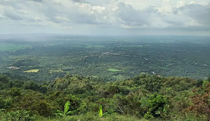
There are some awesome views of the Binh Phuoc forest area and neighboring small towns.

How to Get There: Hire a private driver and head to the start of the trail either at the bottom of the Ba Ra mountain where the traffic circle is or at the parking lot. From Ho Chi Minh City to Binh Phuoc, allocate a travel time of 4+ hours one-way by car.
Admission Cost: Free
12. Ta Cu Mountain
Location: Thuan Nam, Binh Thuan Province
Distance: 7.2 kilometers (4.5 miles) round trip | Duration: 2.5-3 hours to complete the round trip hike with breaks | Difficulty: Easy-Moderate
If you need a change of pace from Mui Ne’s beaches, head to Ta Cu Mountain (Núi Tà Cú) to see the largest reclining Buddha in Southeast Asia.
Ta Cu Mountain is a part of the TTC World Ta Cu tourist attraction that also has a beautiful outdoor garden and children’s rides.
Hiking Ta Cu Mountain is peaceful since there isn’t anyone on the trail. You’ll walk through the forest area and enjoy the quietness.
You may even come across some monkeys along the trail. Just be sure to put away any belongings that are hanging out since Vietnam’s monkeys are notorious for stealing things!
Once you reach the top of the mountain, you’ll need to climb a stairway to see the reclining Buddha. It’s incredible to see the white Buddha perched on a stone slab. Plus, the Buddha is super clean and well-maintained.
Buddha is located at a height of 476 meters (1,564 feet) while the summit is at 649 meters (2,129 feet). Most people do not continue with the hike to reach the peak.
From the Buddha statue, you can visit a small cave with a praying area. Or head back down the mountain.
For the non-hikers, there is a cable car available and a pick-up by electric car to the cable car station. You can take the cable car back down the mountain but you’ll pay for a round-trip fare.
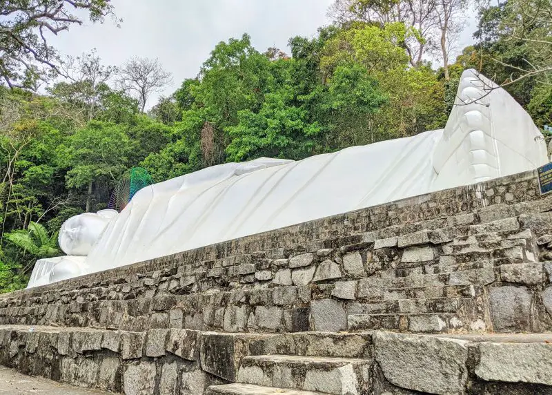
Here is the famous reclining white Buddha.
How to Get There: The closest area to Ta Cu is Mui Ne and it’ll take over an hour by car or motorbike to get to the Ta Cu entrance and parking lot.
Admission Cost: 50,000 VND ($2.20 USD) Adults, 30,000 VND ($1.30) Children (1-1.4 meters) for hiking only
13. Cam Mountain (Forbidden Mountain)
Location: Tinh Binh, An Giang Province
Distance: Various depending on starting location and can be around 14 kilometers (8.70 miles) round trip | Duration: 2-4 hours round trip | Difficulty: Challenging
One of the memorable hikes that we’ve done in South Vietnam is Cam Mountain (Núi Cấm, Thiên Cấm Sơn, or Forbidden Mountain). Located in the offbeat spot of An Giang Province, Cam Mountain is considered the highest peak in the Mekong Delta area at 716 meters (2,349 feet) high.
Hiking Cam Mountain is not typical since most visitors take a cable car to reach the Cam Mountain tourist center. Yet, it shouldn’t deter you from hiking to this spot!
The adventurous way is to walk through a residential area and climb the very steep path (about 40% grade) to the Phat Nho Pagoda. This is the hardest part about the hike.
Tip: The trail isn’t easy to find so it’s best to go with someone who can speak Vietnamese and can ask around.
When you start the trail, there is a collection of bamboo sticks. Grab one since you’ll need one to help with ascending and descending the mountain.
The trail is a combination of dirt and paved path yet you’ll need to share the road with motorbikes descending. Once you reach the pagoda, you continue the walking path for another 5 kilometers (3.2 miles) and walk along a side road until you reach the main road leading to the Cam Mountain tourist center.
Another way is to follow the main road where the cable car entrance is.
Once you reach the top, enjoy the Cam Mountain attractions such as the lovely pagodas and the big white Buddha. It’s one of the top places to visit in the An Giang area!
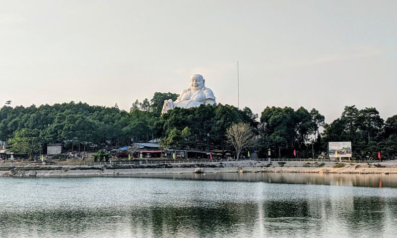
Visiting the Big Buddha is a highlight at Forbidden Mountain (Cam Mountain).
How to Get There: There are different ways to reach the summit of Cam Mountain (where the tourist attraction whether you start on the main road to lead to the tourist area or from Phat Nho Pagoda (Chùa Phật Nhỏ) route.
Admission Cost: 20,000 VND ($.88 USD) Adults for hiking only.
14. Bu Gia Map National Park
Location: Bu Gia Map, Binh Phuoc Province
Distance: Various – Around 12 kilometers (7.5 miles) over 2 days | Duration: Over 2 days with lots of breaks | Difficulty: Easy to Moderate
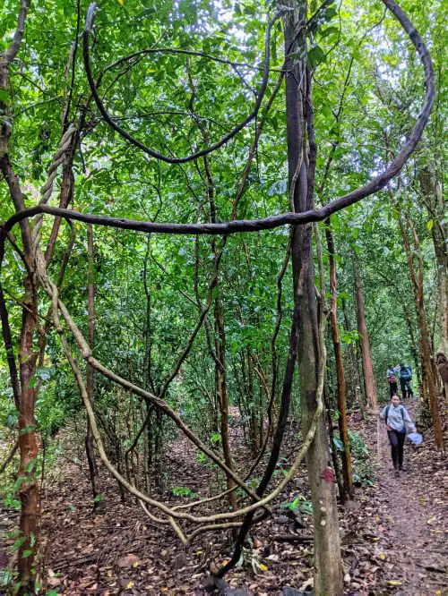
Bu Gia Map National Park (Vườn Quốc gia Bù Gia Mập) is a smaller national park in South Vietnam where visitors spend their days hiking through the forest and streams, camping, and relaxing by the waterfalls. Many visitors spend at least 2 days / 1 night here.
Hiking through this national park is great for beginner hikers as the trail is easy. Therefore, young children can participate in this adventure.
On the first day, the hike is through the forest area and hikers see gorgeous foliage and unique tree branches. There are some steep downhills, but it’s not too bad as long as hikers go slowly. Everyone hikes to the campground where the tents and meals are prepared.
On the second day, the hike is flat and goes through the ankle-high streams to reach the lunch spot. Walking through the streams is refreshing. The only thing to watch out for is the uneven rocks and boulders in the water.
How to Get There: From Ho Chi Minh City, you’ll need to take a car or minivan to Bu Gia Map National Park. It’ll take over 4.5-5+ hours one-way to get there as it’s 200 kilometers (124 miles) away.
Admission Cost: The cost of the National Park is included in the tour, including the National Park guide. Expect to pay around 2,500,000 VND ($107) per person for a tour.
We hope you consider going on one or more of these best hiking trails in Vietnam and feel more prepared to climb these mountains. We’ll continue to add to this list when we go on more trekking adventures.
If you have any questions about any of these hikes, ask a question in the comment box below.
Need more ideas on how to plan your Vietnam travels? Check out our comprehensive posts below.
Save this post to your Vietnam Pinterest board.
 |
2 comments
Vietnam is one of the best places to visit. I love travelling and am thinking of visiting this beautiful country with my friends.
Hope you can visit Vietnam once the borders reopen! I’m sure you and your friends will love traveling through this beautiful country.